
Two of the best things that has ever come to Google, is Google Maps and Google Earth. Each of the two work together and have paved a new view on finding directions easily. Google Maps/Earth makes traveling a little easier and viewing the world up close giving way to exploration. I have always used Google Maps before a trip besides using a GPS to know where I'm going street by street view, so I don't miss the specific destination. Google keeps improving it more to the point it may seem a little scary if someone is wanting to check out your home haaaaa, but the image quality is a lot more clearer and sharp with the street views.
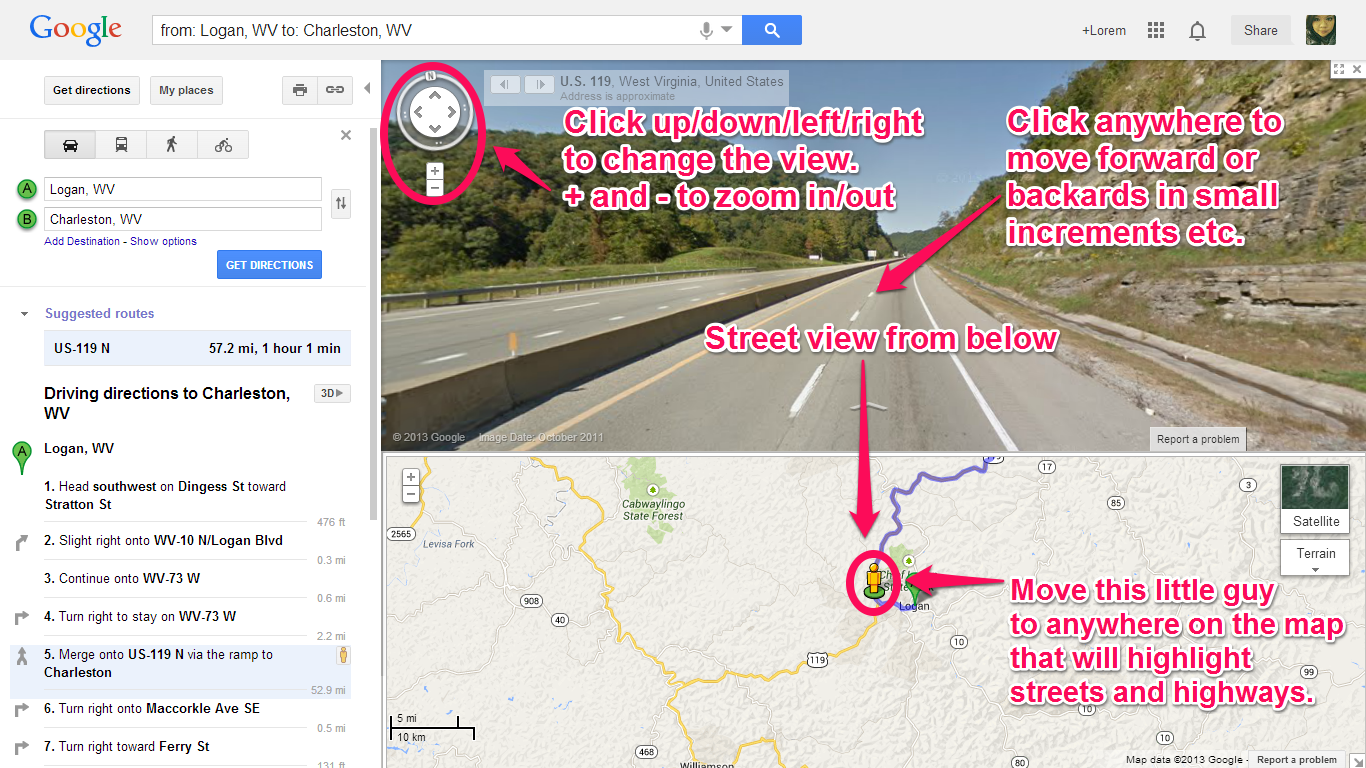
Directions are easy to follow and interacting with the map is simple to do on the browser:

The one thing I never noticed with using the Google Maps is it saves every destination you searched for in it. It still had a list of all the places from months ago still saved on the site itself.

The street views keep expanding more to even places beyond such as the "boonies," but there is still tons of roads you can't view. The street views really show the surroundings of where you're driving which is basically a full 360° view.

You can view before heading out whether there is traffic, weather conditions, accidents, and so on by clicking in the top right corner in the picture below. You will have the option of whether which type of map to view your trip: Satellite, Earth, and regular map view.

Below is the view of the project for class of the camping trip our class is doing by using Craiglist to buy an RV, etc. using Google Maps to pinpoint the places to visit. This is a way to plan a trip beforehand. It is shared to the whole class by my teacher for all of us to pin the areas live.

It's really cool that you can customize your pins and be able to do this with the class editing it together.

Google Earth, is a pretty amazing program to play around with because you see the world in the 3D and you can even look into space which I love to do. I also like using the program to view small islands across the world and looking up about the country that even have pictures placed within the area to view. I look at other places around the world that a typical person hasn't heard of before. I look around the place up close exploring and even viewing airline tickets just to see how much it would cost to travel there. Anyway, you have the option of using the desktop program, browser, and mobile.

The desktop program you can do a number of things and the layers
provide a variety of other places/items to view:

As I mentioned earlier, anywhere you look on the desktop program, it will list pictures of users who have traveled there and posted it which is such a nice feature. The only issue is some are not accurate pictures from that area especially in the middle of the ocean which I have noticed.

You can view the historical map which shows what the area looked like back in 1996. The picture below shows Logan, WV in 2011 with the new stores and restaurants built. Then it shows below it, a view of it in 1996 when it was nothing but a hill.

Well, that was just the start of talking about Google Maps/Earth because there's so much more things you can do with each that I haven't even gone over. Traveling is really made easy anymore without having to go old school with using regular atlas maps. I know they will come up with something even more advanced with the maps throughout the years because Google seems to amaze me more each year with their products.


0 comments:
Post a Comment